")
The project to build a road connecting DT354 (Tien Lang district) to National Highway 10 (Vinh Bao district) with a total length of 8.1 km, is expected to be implemented from the first quarter of 2024 and completed in 2026.
The Hai Phong Traffic Construction Investment Project Management Board has just prepared a summary report on environmental impact assessment (EIA) and sent it to the Ministry of Natural Resources and Environment for appraisal for the district DT354 road construction project. Tien Lang to Highway 10, Vinh Bao district. The consulting unit that prepares the report is the Center for Environmental and Rural Development Consulting.
Previously, in October 2022, the City Council. Hai Phong has approved Resolution No. 62/NQ-HDND on investment policy on this route, implemented in the period of 2022-2026.
The route will have a length of 8.1 km, passing through the territory of Tien Lang district, Vinh Bao district. The starting point (Km0+000) intersects Km10+400 Tel.354, in the territory of Tien Lang town, Tien Lang district; The end point (Km8+100) intersects Km 48+878 National Highway 10, located in Vinh An commune, Vinh Bao
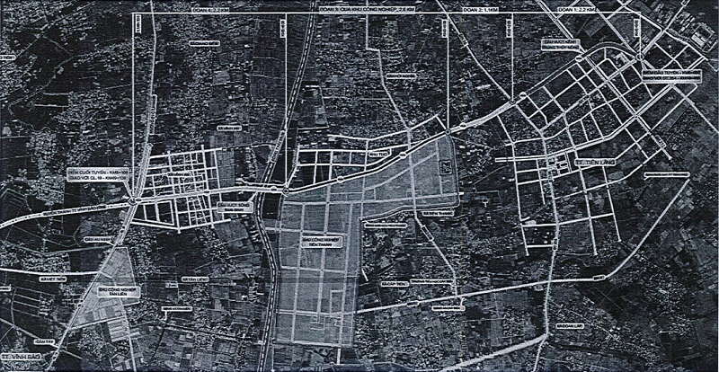
Project route map.
In terms of progress, in 2023, the project will focus on site clearance. From the first quarter of 2024 to the fourth quarter of 2025, the bridge and road section will be constructed (24 months), completed in 2026.
The total investment for this project is more than 1,396 billion VND, of which the cost of compensation and resettlement support accounts for 475 billion VND, construction cost accounts for 722 billion VND...
The whole route will pass through the administrative boundaries of 4 communes/towns, including Tien Lang town, Quyet Tien commune, Tien Thanh commune (Tien Lang district) and Vinh An commune (Vinh Bao district). This is a group B project, with a scale of grade II plain road with a design speed of 100 km/h.
The project will create a new route connecting National Highway 10 to the city center and in the future will connect National Highway 37l; connecting from National Highway 10 and DT354 with industrial parks (IZs), industrial clusters (CCNs) in Tien Lang district, especially Tien Thanh Industrial Park. Shorten the journey between two localities, reduce transportation costs, bring economic efficiency to businesses, promote socio-economic development of the locality and region.
In addition, gradually perfecting the system of traffic infrastructure in Vinh Bao and Tien Lang districts and the traffic network connecting urban and rural areas in the southeast of Hai Phong city; connecting with the coastal area of Thai Binh province, forming a transport system connecting the region, contributing to reducing traffic load through National Highway 10. Forming a space to develop urban framework infrastructure, attracting domestic and foreign investment capital to invest in economic development in the region, creating a premise to promote socio-economic development of the city.
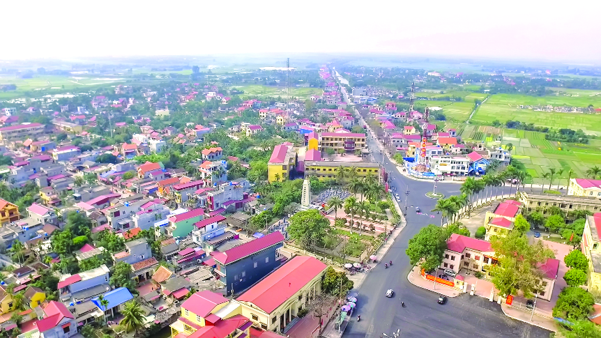
An urban corner of Tien Lang district. Photo: TK.
According to Hai Phong Traffic Construction Investment Project Management Board, the route will be divided into 3 sections: Section 1 (DT354-district 25 road); section 2 (University25-Tien Thanh Industrial Park); section 3 through Tien Thanh Industrial Park and section 4 from the end of Tien Thanh Industrial Park to National Highway 10. In which, the starting point is from the DT354 intersection area with the road to Hoang Ha Paper Factory; The route then cuts through the concrete structure casting station of Hai Dang Construction Trading Joint Stock Company, turning left through the field area to DH25. From the intersection of DH25, the route goes to the north of the town cemetery and Tien Lang bus station. This section is proposed as a route to avoid ground clearance (clearance) of the grave area for the entire 50.5 m expansion phase in the future as planned.
The section from DH25 (Cau Ca area) to the border of Tien Thanh Industrial Park, the line going to the left of Kim Doi canal is an irrigation canal (axle canal II). The end point of the route connects to National Highway 10 to form an intersection at the same level of a junction with canalized traffic islands.
For sections 1, 3 and 4, the route will have a cross section of 22.5m, of which the road surface runs 15m. For section 3 through Tien Thanh Industrial Park, the route has a cross section of 11.25m, of which the roadbed is 7.5m wide.
The intersection with DH25 is the intersection. The current width of DH25 is 12m, the road is planned to widen to 21m. The current intersection with National Highway 10 has mainly field terrain, the immediate phase will be a crossroads intersection, in the future it will be a crossroads when extending the route to avoid Vinh Bao town. National Highway 10 currently has a road surface width of 20.5m. When forming a 4-way intersection, the design of different-level intersections will be studied.
Besides the intersections, on the route will build 2 bridges. The first is Tien Thanh Bridge, which crosses the Thai Binh River, connecting Tien Thanh Commune with Vinh An Commune. This bridge will have a length of 446.5m and a width of 22.5m. The second bridge is a bridge over Trung Thuy Nong canal, planned to be built in Tien Lang town, about 550m upstream of Minh Duc bridge.
To implement the route, TP. Hai Phong will relocate 28 households in Tien Lang district, Tien Lang town, Quyet Thang commune, including 25 main households and 3 auxiliary households. The resettlement planning plan is expected to be implemented simultaneously with the resettlement area of Tien Thanh Industrial Park.
For Vinh Bao district, the number of households that have to be relocated is 30 households, of which there are 16 main households and 14 auxiliary households, mainly in Vinh An commune. The resettlement option will be to build a new resettlement area in the area opposite the kindergarten in Vinh An commune, which is currently agricultural land. This land has an area of about 1ha, construction density of 40%, meeting the resettlement needs of 30 households.